|
|
Post by kev on Aug 9, 2015 20:58:42 GMT 1
Does anyone have a zoomed in map for Pacifica?  |
|
|
|
Post by Julian on Aug 9, 2015 20:59:08 GMT 1
United Islands Of Ermy Map And Regions Names Green = Εmmily Purple : Stone Of Light Red : Stone Of Dinosaurs Pink and Brown : Curusio Islands Emmily Emmily is the biggest island of UIOE ! There is also the capital callem Bume . More Than 5000 people live there and they hope for a better future with peace at fantasia world Stone Of Light Stone Of Light is the 3rd biggest island ! there are actually less than 1000 people as the light is to strong there to live ! You can find there a rare tree called *Maleficius* that there isnt any chance to find it to the fantasia worldStone Of Dinosaurs Stone Of Dinosaurs is the 2nd biggest island of UIOE ! There are actually no people as there are only dinosaurs ! no one is allowed to go there as there are very dangerous dinosaurs as Lenosaurus and Wenosaruas
Curisio Islands
They are actually almost independent tropical islands that want to go away of UIOE ! They are fully of tourists every year as they are the most aphrodisiac of the Fantasia IslandsNo offence, but your islands sound more like the world of a fantasy movie than a realistic country for me  |
|
|
|
Post by Deleted on Aug 9, 2015 23:05:39 GMT 1
 Áredival (meaning "the land of Árs") is a tiny island state located nearly halfway between Westmont and Centralia. It comprises six islands, which are all inhabited. The total population of the state is just around 106,000 people. The capital and the biggest settlement is Árteiaben (eng. Árs' Haven) - around 26000 people live here. All in all there're just 9 towns whose population exceeds 3000 and 5 of them are located on the island Nídanstró (eng. Nidan's Isle). Ár is the demonym and Áredian (or Ársarian) is the official language of the state. The only minority language is Énárian, which is spoken on the three eastern islands; sometimes it is considered as a dialect of Áredian. Engju is taught in schools all over the island, so the islanders are quite proficient in it. The main industries of the island are fishing and natural resources. All the islands are bound together by the ferries which course regularly between the islands. The only airport is located on the Nídantró, just north of Árteiaben. All the settlements above 100 people have access to the roads' network; also there's a railroad with trains and freights operating between the capital and the second biggest city, Remenshaben. |
|
Paulina
Retired Administrator
601
579
Less active in September due to studies
|
Post by Paulina on Aug 10, 2015 2:11:31 GMT 1
Here is the map of  Delinia I started a while ago but never got around to finish until now.. No funny names, just random Swedish sounding  Click here Click here for larger.  Click here Click here for the empty colorable version. I will make regions later. |
|
|
|
Post by Deleted on Aug 10, 2015 11:22:16 GMT 1
I like Sureborg sure, it's en borg  |
|
Daniel
Retired Administrator
He/any
18,846
55,119
Dell powers
|
Post by Daniel on Aug 10, 2015 11:30:52 GMT 1
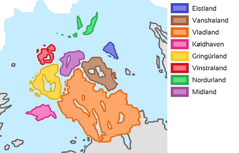
Stadur of Scandavia'Stadur' means 'state' in Scandavian. There are 8 states in total, 7 island states and
one big mainland state. Here you can see the states on the map. |
|
|
|
Post by Julian on Aug 10, 2015 19:20:41 GMT 1
I'm such a flop, I named one of my states "Nordåst" although it's located in the northwest  |
|
1,942
5,805
Our first caress
|
Post by Mordecai on Aug 11, 2015 7:08:29 GMT 1
 GLARAYREGIONS GLARAYREGIONS
Glaray has three regions, divided by language - this is because in ancient times, Imeri Glaraians' territory was split into two by the land controlled by Viera Glaraians (hence the three crowns on the flag, as well as the yellow horizontal strip separating the two red strips on the flag). While originally the Imeri Glaraians from both regions spoke the same language, due to cultural influence by the Viera Glaraians and the brief isolation of the Vallese region after it fell into a brief period of communism, the regions speak different but very similar dialects.VALLESE (Population 2,001,314)Main cities - Alletra, Vallesa, ThazhIMERI (Population 1,372,065)Main cities - Venetra, Rilen, SallaukaVIERA (Population 7,479,384)Main cities - Tusaun (capital), Vetrano, Vazh, Veranta, Ritorno, Rispere, TrientiPERONI ISLANDS (Population 237,195)Main city - PeroniTOTAL POPULATION: 11,090,058 (2014)
5 LARGEST CITIES BY POPULATION
Tusaun 1,373,417Rilen 1,076,312Vallesa 736,212Vetrano 715,047Vazh 682,459
CITIES
 More information on notable Glaraian cities:TUSAUN is the capital of Glaray. Home to 1,373,417 people (in the 2014 census), it is the most populous city in the country. The home of the Glaraian unification movement, the city speaks standard Glaraian and not a variated dialect of the language, common around the rest of the country. It is the country's financial and economic hub. The city is notable for its high skyscrapers, vibrant nightlife and its numerous music festivals held throughout the year.RISPERE while only having a population of 56,230, is important in Glaray as it serves as the main city serving to the Peroni Islands (several islands of the coast of the country belonging to Glaray). It is also recognised as the tourism city of the country, receiving over 80% of the country's tourists. This is attributed to the city's beautiful sandy beaches, crystal clear water and food & wine. The city has also integrated into speaking standard Glaraian. More information on notable Glaraian cities:TUSAUN is the capital of Glaray. Home to 1,373,417 people (in the 2014 census), it is the most populous city in the country. The home of the Glaraian unification movement, the city speaks standard Glaraian and not a variated dialect of the language, common around the rest of the country. It is the country's financial and economic hub. The city is notable for its high skyscrapers, vibrant nightlife and its numerous music festivals held throughout the year.RISPERE while only having a population of 56,230, is important in Glaray as it serves as the main city serving to the Peroni Islands (several islands of the coast of the country belonging to Glaray). It is also recognised as the tourism city of the country, receiving over 80% of the country's tourists. This is attributed to the city's beautiful sandy beaches, crystal clear water and food & wine. The city has also integrated into speaking standard Glaraian.
VENETRA, the Imeri region's second largest city with a population of 418,319 is incredibly important to Glaraian culture as it is believed to be the birth of Imeri Glaraians - hence the strong traditions that continue to be held by the city. The oldest city in Glaray, it has slowly transformed from an ancient, traditional city into a modern one, however traditional infrastructure remains due to the strong cultural ties.RITORNO (literally means 'return' in Glaraian) - Located right on the border of the Vallese-Viera region, the city gets its name from the mass immigration from the Vallese region soon after it became a communist area. The migrants were settled here, right on the Viera-Vallese border. It is one of the poorest cities in Glaray due to the high crime rates in the city after it was built, as well as the harsh treatment from the Viera Glaraians.
SALLAUKA, with a population of 216,485 is important as it is located where the War of Glaray occurred. The city today continues to exist divided by both Viera and Imeri nationalists, and is said to be the main reason why both ethnic groups have failed to live peacefully alongside each other.
The PERONI ISLANDS are a critical part of Glaray's and its neighbours' economies as it serves as the main hub of trade between the surrounding countries. It contributes 27% of Glaray's total GDP.
|
|
|
|
Post by Deleted on Aug 17, 2015 12:37:26 GMT 1
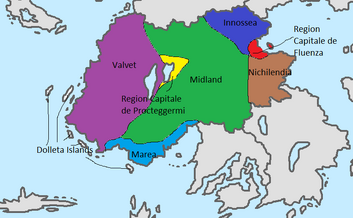
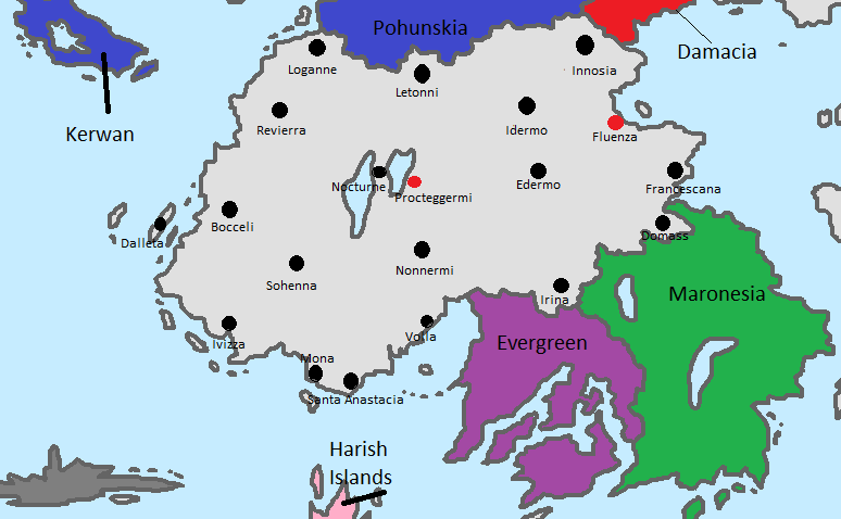
 Assasini Biggest City Map Assasini Biggest City Map    Assasini Regions Map Assasini Regions Map  There are 8 region in There are 8 region in  Assasynia! Assasynia!
Region Capitale de Fluenza and Region Capitale de Procteggermi are Capital Regions.They rule over the country!Fluenza has a pearlament while Procteggermi Court!
Valvet Territory is rebellious territory where people wants to change the rulership and make it republic!Capital is Nocturne.
Marea is a territory where are most coastal city and where people go to take a swim in the beautiful ocean.Capital is Mona.
Dalleta Islands are group of islands where Capital is Dalleta.
Midlandia is a in mid of the country.Wheat and simmillar fruits are mostly produced there.Capital is Letonni.
Innosea and Nicholendia are where are Domacians,Evergreens and Maronesians moslty live there and tat is why they have a small autonomy.Capital of Innosea is Innosia while of Nicholendia is Irena.
|
|
628
1,673
elle vit apparaître le matin. elle se tut discrètement.
|
Post by Kyron on Aug 30, 2015 6:29:32 GMT 1
ISLANDS (REGIONS) OF HARISH ISLANDS

Pepsi Island
Milka Island
Yogo Island
Lays Island ... Please no foods or drinks again ;_; Makes sense, since Fantasia lol  |
|